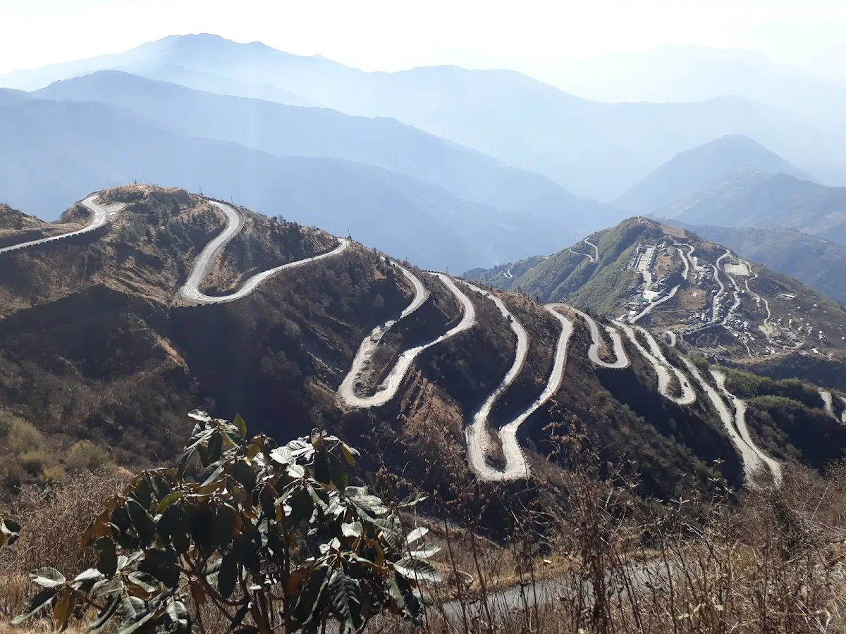
From a single ridge above Zuluk, you can see 32 hairpin bends stacked up the mountainside like a dropped ribbon. That viewpoint, Thambi, is the postcard image of the silk route Sikkim circuit in East Sikkim, the old trade road that once carried wool, salt and silk between Tibet and the plains of Bengal. Today it carries a few hundred travellers a season, almost all of them Indian, almost all of them on a permit arranged the day before in a small town called Rongli.
This is not the Sikkim of Gangtok cafes and MG Road. It is a high, cold, homestay-only stretch of border country where the last reliable mobile signal is far behind you and the road tops out near 14,000 feet. Axomor has catalogued 250+ places across Northeast India, and the Silk Route remains one of the few that still feels genuinely remote. Here is how to do it properly in 2026.
What the Silk Route Actually Is
The “Old Silk Route” through East Sikkim is a branch of the historic trade network that linked Lhasa to the Bengal plains via the Jelep La and Nathu La passes. The Sikkim leg runs roughly from Rongli up through Padamchen, Zuluk, Nathang (Gnathang) Valley, Kupup and Tsomgo Lake, exiting toward Gangtok or Nathu La.
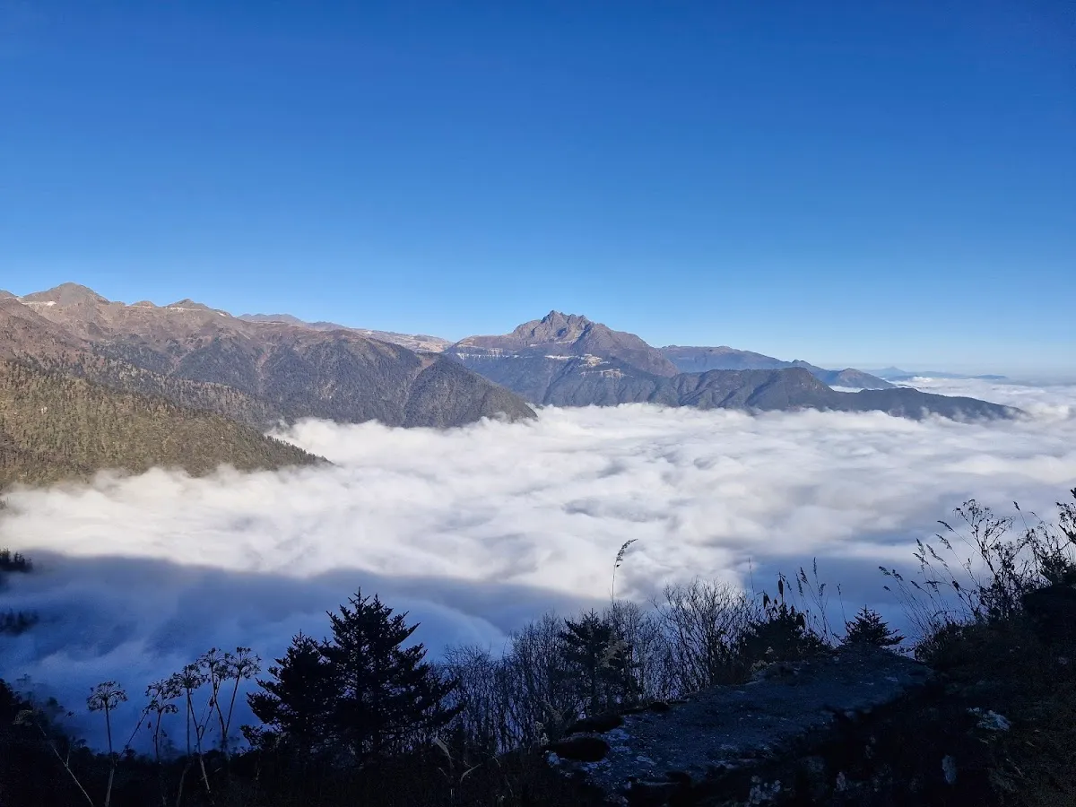
What draws people now is the road itself and the landscape it climbs through: alpine meadows, frozen lakes, an old army bunker turned shrine, and uninterrupted views of Kanchenjunga at sunrise. The circuit sits inside a Protected Area along the India-China Line of Actual Control, which is exactly why it stayed off the tourist map for so long, and why the permit rules below matter.
The Permit: Read This Before You Book
The Silk Route is not a place you can drive into on your own. The whole circuit, Zuluk, Nathang, Kupup, Old Baba Mandir and Nathu La, needs a Protected Area Permit (PAP), and there are firm conditions.
- Indian citizens only, in practice. Indians can do the full circuit with a PAP. Foreign nationals are generally not issued permits for the deep border points (Zuluk, Nathang, Kupup, Baba Mandir, Nathu La), even though they can visit Tsomgo Lake separately. If you hold a foreign passport, confirm with a registered Gangtok operator before booking anything, because these border rules shift.
- Minimum two people. The PAP is issued to a group of two or more. Solo travellers join an operator’s group.
- Arranged through a registered Sikkim operator, not by you directly. Rongli is the dedicated permit and check-post town for the Silk Route, and most Gangtok-based operators process the paperwork there on the way in. Carry a government photo ID (Aadhaar, Voter ID or passport), passport-size photos, and ID copies for every traveller. If you bring your own vehicle, it needs a separate permit too.
- Cost. Agent processing fees are commonly Rs 200 to 300 per person, though some operators quote a permit-service fee of Rs 500 to 1,500. These are operator-set, not a fixed government tariff.
One thing most guides bury: the threat to your trip is rarely the circuit itself. It is NH-10, the Siliguri-to-Gangtok lifeline along the Teesta. After the October 2023 glacial lake outburst flood, that highway has had recurring closures and repair shutdowns through 2025 and into 2026. The Silk Route roads up top are BRO-maintained and usually fine in season. Getting to them is the gamble. Build a buffer day and check NH-10 status before you travel.
The Route, Bend by Bend
Most itineraries enter via Rongli for permits, then climb to Padamchen and Zuluk (around 10,100 ft) for the first night. Sleeping at Zuluk before going higher is not just convenient, it is the natural acclimatisation step.
From Zuluk the road begins the famous Zig-Zag, 32 hairpin bends carved up the mountain. All 32 line up in a single frame from Thambi View Point at around 11,200 ft, the spot you have seen in every photo of this route. Just above it, Lungthung sits higher still and gives the cleaner sunrise over Kanchenjunga.
Beyond the bends the land flattens into Nathang (Gnathang) Valley at roughly 13,500 ft, a treeless high plateau that gets compared to Ladakh and turns white from December. Then comes Kupup Lake, also called Elephant Lake for its shape, and the Old Baba Mandir, the original bunker shrine to Harbhajan Singh, separate from the more visited new temple lower down.
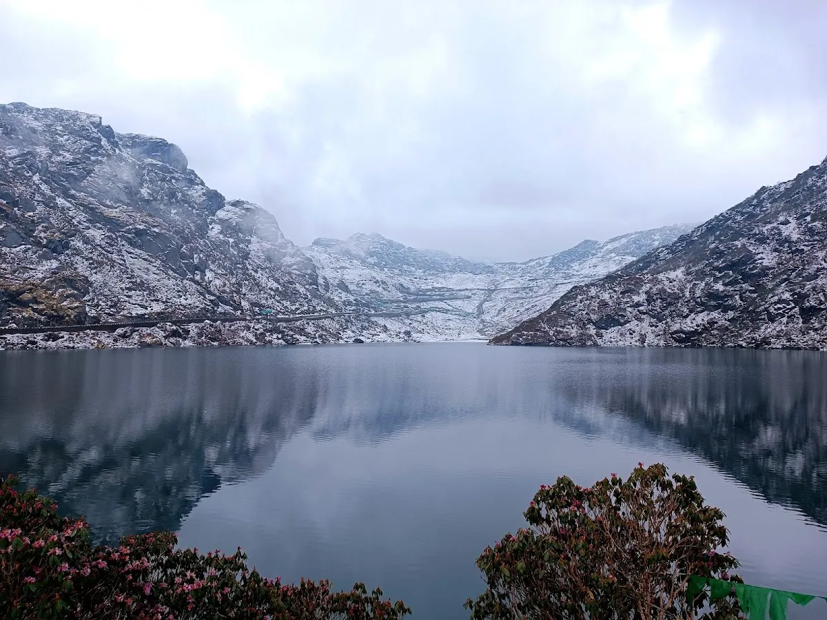
The circuit usually exits past Tsomgo Lake at 12,400 ft toward Nathu La at 14,600 ft, the Indo-China border pass. Note that Nathu La needs its own separate permit on top of the Silk Route PAP and is closed Mondays and Tuesdays, so sequence that day carefully.
Best Time to Visit the Silk Route
| Window | What to expect |
|---|---|
| Dec-Feb | Heavy snow at Nathang, Kupup and Lungthung. The route often shuts for stretches; permits may not be issued. Snow-seekers go, but plans break without warning. |
| Mar-May | Prime season. Snow thaws, rhododendrons bloom across Nathang in April-May, skies are clear. Best for the Thambi sunrise. |
| Jun-Aug | Monsoon. Green and dramatic, but the highest landslide and roadblock risk. Permits get restricted when roads close. Avoid for reliability. |
| Sep-Nov | The clearest views of the year. Sharp Kanchenjunga mornings. Early-to-mid November is the sweet spot to catch first snow while roads are still open. |
Nathang reliably holds snow from December into March, with first snow possible from November.
Altitude and Staying Safe
The Silk Route climbs fast, and altitude sickness is a real risk above Zuluk. The standard itinerary, sleep low at Zuluk first and gain height by day, exists for a reason. Do not jump straight from the plains to a night at Nathang.
| Point | Approx elevation |
|---|---|
| Zuluk | 10,100 ft |
| Thambi View Point | 11,200 ft |
| Lungthung | 12,500-13,000 ft |
| Tsomgo Lake | 12,400 ft |
| Nathang Valley | 13,500 ft |
| Kupup / Elephant Lake | ~13,000 ft |
| Nathu La | 14,600 ft |
Hydrate, skip alcohol the first night, ascend gradually, and carry any personal medication. There are no medical facilities on the route, so altitude-sensitive travellers sometimes carry a small portable oxygen can, which is not stocked locally.
Where to Stay
This is homestay country. There are no hotels in Zuluk or Nathang, only family-run homes, usually booked as part of an operator package or directly by phone when signal allows. Expect basic but warm rooms, thick quilts, and limited heating. A few homestays have geysers; most provide hot water by the bucket on request. Dinner and breakfast are normally included.
Rough 2026 rates run around Rs 900 to 1,500 per person per night at Zuluk including all meals, with better attached-bath rooms higher. Nathang sits in a similar band. Prices rise in the March-May and October-November peaks.
How to Reach the Silk Route
Most travellers base in Gangtok or come up directly through Rongli from Siliguri/NJP. The typical flow is NJP or Gangtok, then Rongli for permits, then up to Zuluk. The circuit is run with local Sikkim-registered vehicles and operators, since the permit system is built around them. Self-driving means an extra vehicle permit, and most people simply hire a Sikkim taxi or SUV with a driver who knows the bends.
Practical Notes Most Guides Skip
- Network is BSNL only, and patchy. Jio and Airtel essentially do not work up here. Tell people at home you will be offline.
- No ATMs anywhere on the route. The last reliable cash point is Rongli; better to withdraw in Gangtok or Siliguri. Homestays and permits run on cash.
- Fuel up early. Rongli and Aritar are the practical last supply points. No pumps up top.
- For the Kanchenjunga sunrise, leave very early. Thambi is a 35 to 40 minute drive from Zuluk, so aim to be at the viewpoint around 4 AM. Lungthung is the higher alternative.
Plan Your Silk Route Trip with Axomor
The Silk Route pairs naturally with a wider Sikkim trip, with Gangtok as the base on either side. For the full state picture, read our guide to the best places to visit in Sikkim, and check the best time to visit Sikkim before you lock in dates. Browse all Sikkim destinations on Axomor to build the rest of the route.
Go while it still feels like the edge of the map. The bends, the cold plateau and that first light on Kanchenjunga are worth every hour of the climb.
Ready to plan this trip?
Use Axomor's free trip planner to build your custom Northeast India itinerary — with distances, permits, and the best time to visit each spot.